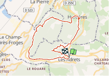
![](/images/other/stat-length.png)
![Randonnée Marche Les Adrets - Crêt de Chazay - Photo](https://media.geolcdn.com/t/1900/400/d66e7447-a4e4-4c95-a2f8-ee32e9d0a226.jpg&format=pjpeg&maxdim=2)
Crêt de Chazay
flip38
Utilisateur
![Longueur](/images/other/stat-length.png)
![Altitude max](https://static1.geolcdn.com/siteimages/upload/files/1508320355ic_sort_altitude_max_24dp.png)
![Dénivelé positif](https://static1.geolcdn.com/siteimages/upload/files/1508320355ic_sort_den_pos_24dp.png)
![Km-Effort](/images/other/stat-length.png)
![Altitude min](https://static1.geolcdn.com/siteimages/upload/files/1508320355ic_sort_altitude_min_24dp.png)
![Dénivelé négatif](https://static1.geolcdn.com/siteimages/upload/files/1508320355ic_sort_den_neg_24dp.png)
![Boucle](https://static1.geolcdn.com/siteimages/upload/files/16400158638029165_repeat_loop_refresh_sync_direction_icon.png)
![Marche](https://static1.geolcdn.com/sitytour/trail-icons/101.png)
2h50
Difficulté : Facile
![Scannez ce code QR pour ouvrir la randonnée dans l'application SityTrail](https://capi.geolives.com/qq0zvz2zws4bq2lad0pu/sitytour/trails/2623983/qr.png?size=200)
Application GPS de randonnée GRATUITE
À propos
Randonnée Marche de 10,5 km à découvrir à Auvergne-Rhône-Alpes, Isère, Les Adrets. Cette randonnée est proposée par flip38.
Description
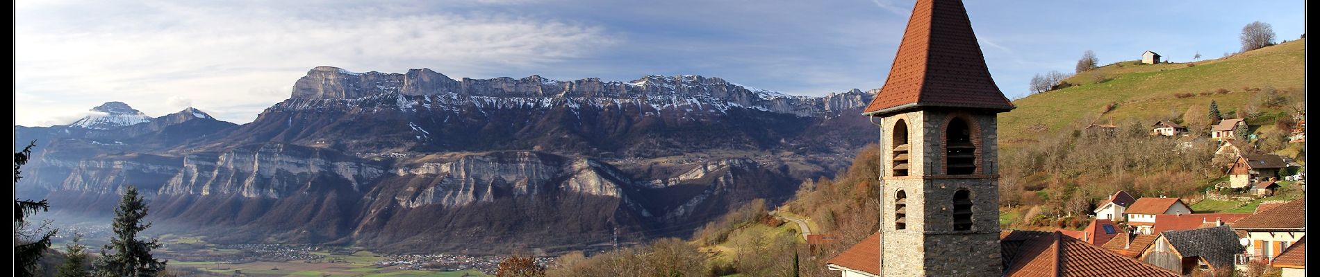
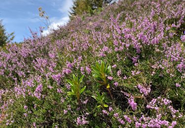
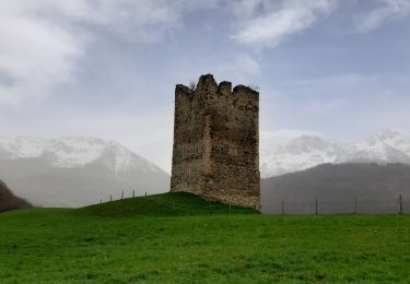
Au départ de l'église des Adrets, encore une belle petite boucle sur les coteaux de Belledonne.
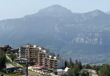
Même si cette boucle se déroule pas mal en forêt, on peut toujours avoir de beaux points de vue sur les massifs environnants.
Le petit sommet du Crêt de Chazay (953m) est le point culminant de cette randonnée.
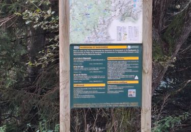
Bons chemins tout le long, parfois un peu gras si le temps est bien humide.
Localisation
Commentaires
Randonnées à proximité
![Randonnée Marche Les Adrets - les 7 laux - Photo](https://media.geolcdn.com/t/375/260/ext.jpg?maxdim=2&url=https%3A%2F%2Fservices.sitytrail.com%2FGeolivesWS%2FDownloadMedia.ashx%3FTrailID%3D210621%26Media%3Dfix__20130806134428.jpg)
![Marche Marche](https://static1.geolcdn.com/sitytour/trail-icons/101.png)
Marche
![](/images/other/stat-length.png)
![](https://static1.geolcdn.com/siteimages/upload/files/16400158638029165_repeat_loop_refresh_sync_direction_icon.png)
![Randonnée Ski de randonnée Les Adrets - le jas de lièvre et vol de Bédina - Photo](https://media.geolcdn.com/t/375/260/fb6d4008-e294-44a8-86f0-b378b0a893a8.jpg&format=jpg&maxdim=2)
![Ski de randonnée Ski de randonnée](https://static1.geolcdn.com/sitytour/trail-icons/503.png)
Ski de randonnée
![](/images/other/stat-length.png)
![](https://static1.geolcdn.com/siteimages/upload/files/16400158638029165_repeat_loop_refresh_sync_direction_icon.png)
![Randonnée V.T.T. Theys - Autour du crêt de Chazay - Photo](https://media.geolcdn.com/t/375/260/ext.jpg?maxdim=2&url=https%3A%2F%2Fstatic1.geolcdn.com%2Fsiteimages%2Fupload%2Ffiles%2F1524743154velo.jpg)
![V.T.T. V.T.T.](https://static1.geolcdn.com/sitytour/trail-icons/202.png)
V.T.T.
![](/images/other/stat-length.png)
![](https://static1.geolcdn.com/siteimages/upload/files/16400158638029165_repeat_loop_refresh_sync_direction_icon.png)
![Randonnée Marche Theys - PROMENADE AUTOUR DU COL DES AYES - Photo](https://media.geolcdn.com/t/375/260/abb3a05c-1892-4f25-9e89-1857c335746d.jpg&format=jpg&maxdim=2)
![Marche Marche](https://static1.geolcdn.com/sitytour/trail-icons/101.png)
Marche
![](/images/other/stat-length.png)
![](https://static1.geolcdn.com/siteimages/upload/files/16400158638029165_repeat_loop_refresh_sync_direction_icon.png)
![Randonnée Marche Theys - BALADE DIGESTIVE APRES UNE FONDUE - Photo](https://media.geolcdn.com/t/375/260/be78689d-589e-4895-90df-62de51c805ee.jpg&format=jpg&maxdim=2)
![Marche Marche](https://static1.geolcdn.com/sitytour/trail-icons/101.png)
Marche
![](/images/other/stat-length.png)
![](https://static1.geolcdn.com/siteimages/upload/files/16400158638029165_repeat_loop_refresh_sync_direction_icon.png)
![Randonnée Marche Laval-en-Belledonne - PETITE RANDONNEE AU DEPART DU PONT DE LA BETTA - Photo](https://media.geolcdn.com/t/375/260/75136744-9eff-4307-a3ab-8becdc263614.jpg&format=jpg&maxdim=2)
![Marche Marche](https://static1.geolcdn.com/sitytour/trail-icons/101.png)
Marche
![](/images/other/stat-length.png)
![](https://static1.geolcdn.com/siteimages/upload/files/16400158638029165_repeat_loop_refresh_sync_direction_icon.png)
![Randonnée sport Les Adrets - Les sept Laux - Photo](https://media.geolcdn.com/t/375/260/305680db-d5bf-44eb-bf28-b61ed10554dc.jpg&format=jpg&maxdim=2)
sport
![](/images/other/stat-length.png)
![](https://static1.geolcdn.com/siteimages/upload/files/16400158638029165_repeat_loop_refresh_sync_direction_icon.png)
![Randonnée Marche Theys - A l’ascension de la roche Noire - Photo](https://media.geolcdn.com/t/375/260/c1f6674c-81f4-4f5e-9550-16c880d7cf83.jpg&format=jpg&maxdim=2)
![Marche Marche](https://static1.geolcdn.com/sitytour/trail-icons/101.png)
Marche
![](/images/other/stat-length.png)
![](https://static1.geolcdn.com/siteimages/upload/files/16400158638029165_repeat_loop_refresh_sync_direction_icon.png)
![Randonnée Marche Laval-en-Belledonne - Boucle Laval - Sainte-Agnès - Photo](https://media.geolcdn.com/t/375/260/6fb48a75-8298-4bbf-bcc4-cbe453c6b40f.jpg&format=jpg&maxdim=2)
![Marche Marche](https://static1.geolcdn.com/sitytour/trail-icons/101.png)
Marche
![](/images/other/stat-length.png)
![](https://static1.geolcdn.com/siteimages/upload/files/16400158638029165_repeat_loop_refresh_sync_direction_icon.png)